Having been on vacation this last week not only gave me the chance to do some paddling, it also gave me the chance to try out a new toy.
When I started this blog, one of the things I wanted to do was to provide photos of the trips to Google Earth via Panoramio. One of the things I quickly found out was that mapping photos of a river trip by hand is a pain in a different body part.
Let's face it, if you've just taken a picture here:

It's pretty easy to tell Google Earth where you were when you snapped the photo.
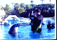
On the other hand, the question "where was I standing when" becomes more problematic when it was somewhere in here:

I want to paddle, not keep track of river bends, so I went looking for something to do this automatically and found this little toy:
This is a simple GPS receiver that just records your location every 15-seconds when it's turned on. Where this becomes useful for photography is when using the included PhotoTrackr software.
PhotoTrackr allows you to select a group of a pictures and a trip record from the GiSTEQ device. It then uses the time the picture was taken to match it up with a location in the trip record and encodes the location in the pictures' EXIF information. Now, when you upload the picture to a service like Panoramio, Flickr or Picassa, those services can read the geotag information included with the picture and map it automatically.
In addition to mapping pictures, the PhotoTrackr software will also map your entire trip on Google Maps or export a KLM file for use with Google Earth -- features I use to create the maps, route pictures and Google Earth downloads for this site.
Overall I'm pleased with the GiSTEQ device. The battery life could be better (1-AA runs it for about 10- to 12-hours) and there are short gaps in the recording. A single trip might be broken into several segments in the software and I've seen some gaps of up to a few hundred yards in the recording. I'm hoping a firmware update will resolve this once I have time to do the update.
I also had a problem with the install. It calls for getting a Google Map API Key (this would be the key the software uses to identify itself to Google Maps for displaying maps within the software). The install process sends you to the Google website to retrieve this key, but the site asks for a web address -- the PhotoTrackr install doesn't make it clear that it's the GiSTEQ website you have to enter here (http://www.gisteq.com/). Once I found that tidbit on the GiSTEQ support forum, everything was fine.


No comments:
Post a Comment