Monday, June 16, 2008

GiSTEQ PhotoTrackr Lite - A New Toy

Having been on vacation this last week not only gave me the chance to do some paddling, it also gave me the chance to try out a new toy.

When I started this blog, one of the things I wanted to do was to provide photos of the trips to Google Earth via Panoramio.  One of the things I quickly found out was that mapping photos of a river trip by hand is a pain in a different body part. 

Let's face it, if you've just taken a picture here:

eiffel_tower

It's pretty easy to tell Google Earth where you were when you snapped the photo. 

On the other hand, the question "where was I standing when" becomes more problematic when it was somewhere in here:

econ_bends

I want to paddle, not keep track of river bends, so I went looking for something to do this automatically and found this little toy:

This is a simple GPS receiver that just records your location every 15-seconds when it's turned on.  Where this becomes useful for photography is when using the included PhotoTrackr software.

PhotoTrackr allows you to select a group of a pictures and a trip record from the GiSTEQ device.  It then uses the time the picture was taken to match it up with a location in the trip record and encodes the location in the pictures' EXIF information.  Now, when you upload the picture to a service like Panoramio, Flickr or Picassa, those services can read the geotag information included with the picture and map it automatically.

In addition to mapping pictures, the PhotoTrackr software will also map your entire trip on Google Maps or export a KLM file for use with Google Earth -- features I use to create the maps, route pictures and Google Earth downloads for this site.

Overall I'm pleased with the GiSTEQ device.  The battery life could be better (1-AA runs it for about 10- to 12-hours) and there are short gaps in the recording.  A single trip might be broken into several segments in the software and I've seen some gaps of up to a few hundred yards in the recording.  I'm hoping a firmware update will resolve this once I have time to do the update. 

I also had a problem with the install.  It calls for getting a Google Map API Key (this would be the key the software uses to identify itself to Google Maps for displaying maps within the software).  The install process sends you to the Google website to retrieve this key, but the site asks for a web address -- the PhotoTrackr install doesn't make it clear that it's the GiSTEQ website you have to enter here (http://www.gisteq.com/).  Once I found that tidbit on the GiSTEQ support forum, everything was fine.

Saturday, June 14, 2008

Wekiva River

After nearly soiling myself passing a very large gator at close range on the Econlockhatchee, I decided something more leisurely and sedate was in order, so I headed for Wekiwa Springs State Park to paddle the Wekiva River.

The springs and the river actually do have different names, it isn't an alternate spelling.  Wekiwa refers to the springs -- water coming out of the ground; while Wekiva means water flowing over the ground.


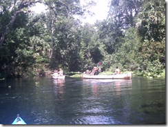
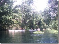
If you want a peaceful, tranquil Florida river experience, the Wekiva is a good choice ... unless it's a Saturday during Summer.  Wekiwa Springs State Park frequently closes due to capacity being reached on Summer weekends and the river teems with boaters ... most of them in rented canoes with no idea what they're doing and less interest in the serenity of nature.

Near the headwaters of the Wekiva you have a choice of putting in at either the State Park or Wekiva Marina (about a mile downstream from the springs).


View Larger Map

I chose the State Park because the fee to put in is a couple dollars less.  If you put in at the Marina and then want to paddle to the Park, there's a small fee to enter the Park as well.

One issue with launching your own boat from the State Park is that the water is some distance from the parking.  There's also a hill involved and the trail is rather soft sand in some places.  It's not that bad getting to the water, since it's downhill from the parking lot ... the bad part comes later.

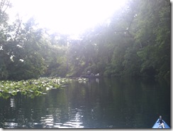
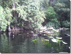
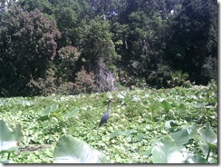
The put-in is on the Wekiwa Springs pond, just below the swimming area.

PICT0075

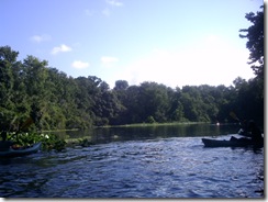
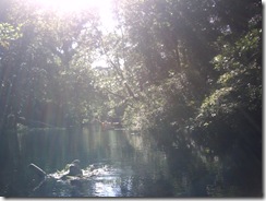
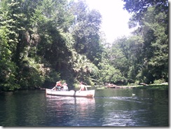
Since my little misadventure on the Econ had eaten up some of my time this morning (and thankfully that was all that was eaten), it was after 9:00 AM when I got to the springs and people were already on the water.  It was still early enough, though to get a bit of mist and early morning sunshine through the trees.

PICT0076

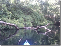
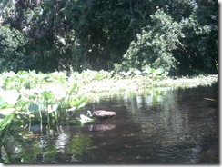
About 3/4 of a mile from the springs, Rock Springs Run joins the Wekiva.  This is a smaller, less-traveled tributary that I enjoy paddling and I started up it a bit before returning to the Wekiva.

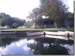
A full mile from the State Park is Wekiva Marina, where you can also put in or rent a canoe.

PICT0079

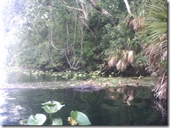
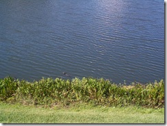
Shortly past the marina, I came across a small alligator -- a much more pleasant encounter than the one earlier in the day.  In fact, on most trips down the Wekiva I've encountered a small gator in this area, just downstream of the marina.

PICT0086

It's at this point in writing this blog entry that I come to the realization that the little Argus Bean camera I got for these trips just isn't going to do it for me.  Most of the pictures I took on this trip didn't come out well, so I'm going to have to try something better. 

After pointing out the little gator to the next group of paddlers coming down the river, I leave him behind and encounter a new form of wildlife -- kayaker without PFD:

PICT0087

If you look closely, you can see her head behind the nice Fish and Game officer's boat ... her head's right next to the officer's ticket book, which she got a very good look at. 

Is it really such a hardship to have a PFD in the boat? 

Past the legal action, I saw bubbles start to break the surface of the water near the shore, then a stream of bubbles race across the width of the river.  A line of bubbles breaking the surface usually means an otter and a bit of patience tracked him down when he surfaced near a fallen tree to munch on a fish.

PICT0091

I love watching otters and had the good fortune to once rent an apartment that had been built around a natural pond that acquired a family of them.  For several months I was able to watch them from the comfort of my balcony:

 DCP00356 DCP00360

After passing the otters, I saw some turtles on a log:

PICT0094

This is the obligatory, Florida, Turtle on a Log picture.  I do not plan to take or post any more pictures of Turtle on a Log, no matter what river I see them on.

Now, don't get me wrong, I like seeing Turtles on a Log -- no matter how many times I see them, it's a nice reminder that I'm on the water, away from the city.  But, let's face it, there're a lot of Turtles on a Log.  And anyone who paddles, especially in Florida, has seen more than their share already, so pictures of them aren't really necessary.

So, from time to time, if I feel it's useful for the ambiance of the trip report, I'll just throw in:

<Turtle on a Log>

You'll know what I mean and it'll save everyone's time and Internet bandwidth.  If you truly feel compelled to see another picture of Turtle on a Log, you can click the link and come right back here to one.

Of course, I'll still take and post a picture if I feel it's noteworthy, for instance if I see Unusually Large Turtle on a Log or Very Large Number of Turtles on a Log.  Definitely if I see the very rare: Log With No Turtle. 

I started paddling again ...

<Turtle on a Log>

(see how nicely that works?)

About 1/2 a mile downstream of the marina, the river appears to split around an island you can recognize by the lone palm tree next to a bare bank:

PICT0097 

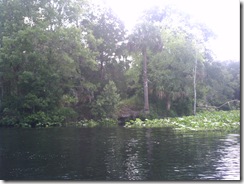
The left channel is the main, navigable river, but the island is a frequent stop to rest and relax.  Farther along its shore are several rope swings and later in the day this spot will be packed with people picnicking and playing in the water.

PICT0098

The rest of my paddle down river is mostly uneventful ...

<Turtle on a Log>
<Turtle on a Log>
<Turtle on a Log>

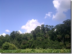
... though I do get my best quality pictures of the day out of the Argus Bean when I come to an open area of the river and want to capture the beautiful sky I'm paddling under:

PICT0100 PICT0101

After a couple hours of paddling ...

<Turtle on a Log> ^ 10

I do encounter some very tolerant birds that let me get quite close for a picture.  These are without any zoom:

PICT0107 PICT0109

Once back between the marina and the park, I once again encounter the large crowds on the river this summer weekend.  The attendant at the springs put-in told me they had eighty boats on the water -- possibly an exaggeration.

One day, I'm going to come here and just paddle the mile between the park and marina, back and forth, all day, watching the people in the rented canoes.  Some know what they're doing, but for others it's a crap-shoot whether they'll make it off the river alive.

Best quote of the day (from a wife in the front of a canoe with a paddle across her lap):

"You're heading right for another tree!"

The tree in question was at least fifty feet away and the look on the husband's face was priceless.

<Turtle on a Log>

My favorite was this lady.  She has three kids with her in two canoes.  She has tied the canoes together and is the only one paddling -- the kids mostly just sit there with their paddles.  Here she is crossing the river in front of me:

PICT0111

Now, here she is crossing the river back the other way:

PICT0112 

And back:

PICT0113

Here the Bean failed me again, but she's recrossing the river right in front of another canoe (keep in mind her two are tied together and the oncoming canoe has the current behind it).  I'm cringing at this point, waiting for the clothesline flag to be thrown and ready to assist the soon-to-be victims.

PICT0114

Luckily, the oncoming paddler was able to slow down enough to avoid disaster.  

Once back at the State Park put-in, the truly horrid part of the trip is facing me: getting the boat back to the car.

After trudging up the hill to retrieve the kayak cart from the car and back down to the put-in, I make sure everything's secure on the boat and start the trek ... uphill ... through the soft, soft sand.

At the top of the initial hill, there's a choice to be made.  I can turn right past the concession stand and then up the narrower, steeper trail to where I parked, or I can go left through a picnic area -- that way is longer, but not as steep.

I'm 41-years old, out of shape and need the exercise, I take the hill.  Besides, they're grilling in the picnic area, I can smell it.  I'm hungry after the morning's paddling and the turkey sandwiches waiting in my cooler just aren't what I want.  If I have to drag this damn boat past burgers and barbeque, there's going to be an Incident.

So up the hill.  But not all at once.  The goal is to get the heart pumping, not exploding.

First, the short pull across level ground to the restrooms, which is an excellent excuse to stop for a moment.  Then start up the hill to the gate and pause again, looking longingly back at the hot dog cart outside the park's concession.  If they were grilled, I'd be all over it, but they're boiled and even the turkey in the cooler's more appetizing than that.

Now up the hill to the halfway point, where I wheeze for a little while, muttering about how if I'd taken the other path I'd be eating a burger right now while fending off its owner with a BBQ fork.

And one final pull to the parking lot where I load up the car and settle in to the air conditioning to eat my turkey sandwich.  Yum.

Econlockhatchee River (lower) -- Failed Trip

The Econ has not been kind to me this week.  After failing earlier in an attempt to paddle the upper stretch, I returned this morning for the lower segment, which is 11-miles and runs from Snow Hill Road to State Road 46, a short ways down the St. Johns River from where the Econ flows into it.


View Larger Map

The put-in at Snow Hill Road is very nice, with gravel entries on either side of the road and under the bridge.

PICT0055 PICT0054

Despite some rain during the week, the water level was still very low when I arrived, so low that the little dam under the bridge was visible.

PICT0059

Water level and debris had been the problem when I tried to paddle the upper segment, but I decided to try anyway.  The current water level had been okay for paddling the middle segment that runs through the Little Big Econ State Forest, so I figured it was worth a try.

Because the shore of the put-in below the little dam is mostly rock and concrete for erosion control, I put in above the dam and "shot the rapids" -- this is Florida, we take what we can get.

Shortly after taking off, only a few minutes down river, I come to a tree mostly blocking the way, but it's been down a while and previous paddlers have cleared some of it near the left bank and there's about six or eight feet of clear water on that side.

As I get closer, I see that there's a stump dead center of this cleared space and it looks over a foot across, so I start pondering how to get by it; is my better track going to be on the left near shore or on the right toward open water?  With the current pushing me toward the gap, I look down river to see what's next and choose my line ... then I notice something and have a new thing to ponder:

Why does a stump need eyes?

This is, indeed, a riddle ... a quandary, even, that I puzzle over as the stump slowly sinks out of sight.

I stop paddling as the current takes me through the gap and I look down.

Under two, maybe three, feet of tea-colored water, half a paddle-length from the edge of my boat, is an eat-me category alligator.  (Actually, from my perspective at the time, he looks more like he's in the Betty White's Cow category.)

He's not as big as my boat, a 16.5' Tarpon, but he's bigger than most of my boat, so my heart's racing a bit.

Now, intellectually, I know that he doesn't want to hurt me and the reason he's down on the bottom is so I won't see him and will leave him alone.  I know this ... but fresh in my mind at the time is this message from over on the Green Wave about a gator surfacing and putting four holes in the bow of 14.5' Perception at Alexander Springs.

I'm sure the gator in that incident wasn't looking to hurt anyone, he just got startled and wanted to get away, so he lashed out at what he thought was the threat and then retreated. 

So here I am floating by my gator today, trying ever so hard not to appear threatening (or tasty).  In fact, I'm thinking to myself: "Hello, Mr. Alligator -- this is just a big, blue log floating innocently down the river; soon it will be gone and you can go on about your business.  Pay no attention to that mammal on top of the log, he tastes bad and is high in cholesterol."

Once past, I breathe a sigh of relief and round the next bend, glad to put him behind me.  As I round the bend, I startle a deer drinking at the shoreline.  She stares at me for a split-second, then bounds off into the brush.  And it's at this point that I remember I have a camera, so I head for the beach where the deer was drinking, tie up my kayak and walk back along the shoreline (keeping some distance from the actual water) until I find the alligator again -- he'd drifted a bit downstream from where I first saw him.  He's still submerged, but is visible in the pictures:

PICT0061PICT0062PICT0063 PICT0064 

As I get back in the boat and start paddling again, I begin to think:

Narrow river + shallow water + large alligators + solo paddler = ?

What do these things add up to?  Stupid people doing stupid things.

See, I have no doubt at all that I've been on the water with gators that big before ... many times.  I've probably paddled right over them.  The difference here is that the water's not deep enough and the river's not wide enough for the gator to get far enough from me for him to feel safe ... and that's when he's going to hurt me, when he thinks I'm a threat and he can't get away.

I'm barely into this trip and I'm thinking about another eleven miles of narrow, shallow water ... what's the likelihood in these conditions that I'll be paddling hard and deep to get around some obstruction and whack one of these guys in the head with my paddle?  Or that I'll be unable to see below the surface ahead of me due to the sun's glare and wind up running into one?  Do I like these odds?

So, since one of my life-goals is to not be the guy on the six o'clock news story that everyone else in town shakes their head and mutters "dumb ass" about, I decide this isn't the right time to take this trip.  On another day, when there's more water and maybe another paddler, I'll be back.

At the time, though, I have another problem.  Ahead of me is eleven miles of shallow, narrow water with an unknown number of large alligators ... behind me might only be a few hundred yards of paddling, but I know exactly what's in the very shallow, very narrow river.

I start paddling back, keeping a watchful eye out ... no gator.  I pull onto the bank a couple times so I can walk ahead and scout the water ... no gator.  I get past the area that I first saw him in ... no gator.  I get to within view of the dam ... no gator.  I get through the gap in the dam, under the Snow Hill Road bridge and up to the beach ... no gator.

So the question in my mind for the rest of the day:  I didn't see him, so how close to the bottom of my boat was he when I went right over him?

Thursday, June 12, 2008

The Boy-Child's First Solo

There's an old Styx song I've been humming a lot this week:

Nothing ever goes as planned ...
It's a hell of a notion ...

I'm on vacation this week and had "plans" -- the plans were to paddle every morning, do several hours of paddling on different routes and be off the water by mid-day to spend time with my family. But, as I keep telling my kids when they whine "But you said we were going to ...", plans change.

Errands, a dog needing to go to the vet and a couple late nights have all conspired to make me skip getting on the water several days.

Now, all week long, the boy-child's been saying that he wants to go kayaking with me and I've been putting him off. Because I've paddled so little over the last few years, I've become a bit jealous of my time on the water. Taking one of the kids means changing the trip to accommodate them -- and I had "plans" for this week.

Taking T. has always meant paddling the tandem Pamlico, which I'm not entirely happy with, and keeping the trip short enough so he doesn't get bored. At nine, hours and hours on a river just doesn't keep him entertained.

But kitten's been reminding me of some things lately (it's not nagging when it's the right thing to do), and that'd been percolating through my brain all night, so when the Big Bad Wolf ...

PICT0051

... stepped on my gut at dawn to say "Morning! Morning! Morning! Time to do things!" ... plans changed.

I still don't like paddling the Pamlico, though, so I decided it was time for T. to try paddling himself. We loaded up the the Tarpon and my daughter's Swifty to head for Moss Park where I'd paddled just a couple days before.


View Larger Map

Earlier in the week I'd paddled Lake Hart, on the West side of Moss Park, but that route starts with a 1/2-mile trip down a relatively narrow (20- or 30-foot wide) channel. I figured that would be a bit much to ask of the boy his first time alone in a kayak, so we paddled the Lake Mary Jane side of the park.

080612-MossPark (view this location in Google Earth)
(get Google Earth)

This side of the park has a nice sand beach and swimming area, as well as a grass launching area suitable for kayaks. Just off the beach is an island that's designated as a bird sanctuary. We put in from this area and started paddling.

I'd almost expected T. to be a bit hesitant about paddling himself, but he took right off, clearing the reeds around the put-in before I was fully in my boat:

PICT0036

I was really impressed by how well he did right from the start. His stroke needs work (so does mine) and his tracking is ... creative (I think he paddled two or three feet for every one I did today), but he took to it quickly.

PICT0037

I let him set the pace and direction for a bit, then suggested he head across the lake toward the nearest boathouse we could see. I expected him to tire out and want to turn back before making it, but he kept going and we made it to the target.

080612-MossParkRoute

The distance to the boathouse from the put-in is about half a mile, but as I said, his paddling paths are interesting, so he probably paddled a full mile on the way over.

Once there, we took a brief rest and he was ready to paddle farther, not the least intimidated by the view back to the beach we'd set off from:

PICT0048

He has a tendency to paddle harder than he needs to, though, so I didn't want to chance him tiring out and needing a tow back. We drifted for a bit, talking about paddling and then headed back in.

Once everything but the Swifty was back in or on the car, we took the it over to the swimming area. If he's going to paddle his own boat, he needs to have some knowledge and be prepared, so I stood in waist-deep water with him in the boat and explained some things like primary and secondary stability. Then I tilted the boat so he could get a feel for it and finally I dumped him over a few time so he could practice a wet exit.

Okay, so he's so short that a wet exit for him mostly consists of falling out of the cockpit as the boat goes over and this was more of an excuse to dump him in the water a few times, but it did give him a feel for it so he won't freak out if it ever happens.

He also practiced getting back into the boat after going over and saw how, even full of water, the flotation bags keep it at the surface. And how much water he'd have to bail out if he ever went over in the middle of a lake somewhere.

Next time, we'll work on keeping control of paddle and kayak when going over. This is also an area I neglected with the girl-child, when she started paddling, so I should work on this with her, too.

Isn't it great when a legitimate safety exercise gives you an excuse to half-drown your children?

Tuesday, June 10, 2008

Moss Park - Lake Hart

After my failure at paddling the upper Econ this morning, I moved on to Moss Park and Lake Hart.


Moss Park is in South Orange County, situated between Lake Hart (to the west) and Lake Mary Jane (to the east).  A canal connects the two lakes, running through the Park:


View Larger Map

MossParkCanal

As of this writing, the entry fee at Moss Park is $3 for one person in a vehicle or $5 for up to eight people.  The boat launch is to the right as you enter the park and there's a grass launch area next to the boat ramp:

Once on the water, you face a 1/2-mile paddle down a channel through the reeds to Lake Hart:

The channel opens up into a pool about a half way through; and once past the channel, you enter the open water of Lake Hart:

And here's where my camera battery died, so the rest of the photos were taken with my cellphone.  In my previous post for today, I explained that my plan is to post the bad of my trips along with the good, so here was the first of the bad.

I've never been much of a photo-taker when kayaking, I prefer to just paddle, but one of the things I wanted to include in this blog was a lot of pictures, so people would have a good idea of what to expect on a given trip.

I didn't want to spend a lot of money on equipment starting out, so I went with a cheap camera, with a bit of water resistance and intended for outdoor use, the Argus Bean.

It's a simple, cheap camera.  My reasoning being, if I dump it in a lake, I don't want it to have cost a lot.  Well, $59.99 at Best Buy isn't a lot, but maybe sometimes you get what you pay for.  So far, I'm not impressed with the camera.  I suppose it takes a decent picture, but this first outing didn't show a decent battery life.  I'm going to make sure it has a full charge before my next trip and see how long it really lasts.

What I'd really like is the Sealife Ecoshot -- waterproof to 75' and shockproof to 6'.  But it costs more than I'm willing to spend right now.

080610-LakeHart

For this trip, I circumnavigated Lake Hart.  The path in the Google Earth screenshot above is incomplete because because of problems with the new GPS, but it roughly shows the route.

View the Route in Google Earth 

Most of the shoreline of Lake Hart is unimpressive -- reeds backed by forest:

080610-LakeHartShoreline

But there are some nice houses along the western shore, including this one, belonging to someone who clearly loves to be on the water:

080610-HouseWithWatercraft By my count, that's a ski boat, two SeaDoos, a canoe (with motor) and a catamaran at his dock.  I have to admit to a certain amount of jealousy.

Then there's this guy:

080610-PalmTreeHouse

This guy buys his lot, then clears it completely and plants palm trees.

There are no, or at least very few, naturally occurring palm trees on the shoreline of either Lake Hart or neighboring Lake Mary Jane, but this guy has to have his palm trees.  Look at how his house stands out as a breach in the shoreline, compared to the houses next door that kept the existing trees between the house and water.

I can absolutely understand the desire to have a home on the water and buying one if you can afford it, but I simply can't comprehend the arrogance of destroying or so significantly altering the very thing your supposed to enjoy.

The paddle itself was an uneventful, but enjoyable, three hours on the water.  The only excitement came near the end, when I realized I was much closer to the southern shore than I should be to find the channel back to Moss Park.  I guess I was distracted or lost in thought, so missed the entry to the channel.

Now, I considered just leaving this bit off and letting everyone assume that I'd simply paddled a little extra distance at the end of the trip, but I'd just this very day decided to be up front about things that went wrong on these trips, so here are my thoughts from the last bit of today's trip, starting from when I realized I'd passed the channel back to Moss Park:

This seems too close to the Southern shore -- did I miss the channel?  No, I couldn't have missed the channel ... I'd have to be blind not to see it; my eyes are playing tricks on me and those houses just look closer than they should -- the channel's probably right around that point of reeds there.  Paddle some more.

Nope, not here.  Damn, I must have missed it -- now I have to turn around.  Turn around and paddle some more.

You know, I was feeling pretty good until I had to turn around ... now it just feels like work, because it's extra distance I wouldn't have had to paddle if I'd been paying attention.  Luckily I didn't miss it by much, I think it's right past those reeds.  Paddle some more.

Well, that's not it either.  It must be around that next outcropping of reeds.  Great, more paddling I wouldn't have had to do.  It's getting hot and my back aches now.  I didn't notice it before, but have since I turned around.  This isn't as much fun as it was. Paddle some more.

Crap! Where is the damn channel?  I've paddled around this lake a dozen times and never had trouble finding it before.  What was the landmark I picked out to look for on my way back?

I don't remember what I picked to look for ... did I forget to look for something to help find my way back?  I must have ... that was silly.  What'd I use last time?  I can't remember ... why can't I remember what I used the other times I was here?  My memory must be going bad, maybe I should start taking Gingko-Biloba.  Paddle more.

Now I'm cranky.  I'm hot, I'm tired and I should be at the boat ramp by now, but I still haven't found the channel ...

Maybe I didn't pass it ... oh ... that would be bad ...

What if I didn't pass it, I just thought I did and now I'm paddling away from it?  And I decided I was going to blog about things that go wrong, so I'm going to have to write about this ... people are going to think I'm an idiot.  The fun's definitely over for this trip.  Paddle more.

Maybe if I pull into this little hole in the reeds and stand up I'll be able to get my bearings better.  Sure am glad the Tarpon's a stable boat, so I can stand up in it ...

Can't see a damn thing over these reeds ... that was a waste of time. 

Where's that bass fisherman I saw earlier?  He could tell me where I'm going -- or maybe give me a tow.  He has a motor ... that's smart; freakin' paddles ... if I had a motor, I'd be done by now.  Why do I have a paddle?  If God had meant for us to keep paddling, he wouldn't have invented internal combustion.  I'm not having any fun!  Paddle more.

I really think I might have turned around too soon -- but if I turn back now, and I really did miss it the first time, then I'll be paddling away.  I could spend the rest of the day paddling back and forth, missing it by fifty yards at either end.  I'm going to have to paddle all the way north and all the way south to find this damn thing -- that's like another three miles just to get out of here.  No fun.  Paddle more.

That's what I was supposed to be looking for:

080610-ChannelMarker A bunch of trees out in the middle of the reeds.  Finally ... now there's just that half-mile down the channel.  That's a relief.

Yeah, a half-mile at noon, in Florida, with the reeds cutting off the breeze ... great <expletive deleted> relief.  I need a motor.  I'm going to sell the damn 'yaks and get a nice 26' Sportfisher with twin diesels and a flying bridge ... that's how people my age should enjoy the water.

Okay ... past the idle speed marker; I'm out of the reeds and under the trees ... the shade feels good ... maybe a hundred yards to the boat ramp.

Out of the boat onto the shore ... the knees are a little stiff ... stretch the sore spot in the back where the top of the seat presses wrong ... should've fixed that years ago ... boy, it feels good to be walking around a little.

You know, that little mishap probably added two miles to my trip.  With the channel and the distance around the lake, I might have done ten miles this morning ... just me paddling.  I can be proud of that.  Bet the guy in the bass boat couldn't do that -- that's why he's got that beer belly.  Freakin' wimp with a motor; motor's are cheating.

Now I have to get the boat on the car and get home so I can unload and run errands this afternoon ...

I wish I could stay and paddle around the other lake ... that was fun.

Econlockhatchee River (upper) -- Failed Trip

If the trip was a failure, why am I posting it?  In fact, if it can't be called a trip at all, with barely twenty minutes on the water, why am I posting it?  Well, here's what happened and why.

I'm on vacation this week and wanted to paddle several different routes to post about, including the full (navigable) length of the Econlockhatchee River.  Last week I paddled the middle segment and really wanted to paddle the upper today, but the upper part of the Econ can be tricky, with low water and a lot of debris.


Over the weekend, I stopped by to look at both of the put-ins on Highway 50 -- Blanchard Park and Hidden River RV.  Blanchard Park is on the Little Econ and Hidden River is on the Big Econ -- the two rivers meet at highway 419, entering the Little Big Econ State Forest (hence the silly name for the forest):


View Larger Map

Blanchard Park was right out -- the water level was very low and every bend was clogged with growth.  There'd be no putting in here.

Hidden River was worse -- I didn't even see the water, just spoke to the manager who told me they weren't putting in because of the low water.

Not to be deterred, I figured I'd just put in at 419 and paddle upstream as far as I could.  I'd just paddled 419 to Snow Hill Road the week before, so I should be able to get some distance upstream from there before it got too bad, right?

Well, about twenty yards up the Little Econ I find the first obstruction -- completely blocking the river, so I have to pull over.  Around the next bend, there's another one and I can see two more beyond it.  Little Econ's clearly not an option, let's try the Big Econ.

Here it's worse -- I get to the first blockage and can see three more beyond it.  One of which I might be able to paddle around, but the others are completely blocking the river. 

080610-EconUpperView in Google Earth
 (download Google Earth)

At this point, I realize I'm not going to paddle the upper stretch today, so I head back and start thinking about what to do instead.  I could pass 419 and paddle the middle-segment again, but I just did that last week and I want something new to blog about.  Besides, since my plan was to paddle upstream and then back, I hadn't made any plans with kitten for her to pick me up. 

So I packed things up and headed to Moss Park to paddle Lake Hart.

Now, why did I bother posting this for a trip that went nowhere when I wound up paddling someplace else?

When I started paddling twenty-some years ago, all the "trip reports" were in magazines.  As I read about those trips and then took my own, I saw a disconnect -- there was something missing.

The stories in the magazines were of only two flavors: the trip either went perfectly or catastrophically.  Meaning, it was all cotton-candy clouds and pink bunnies showing up at the campsite come sundown; or, it was lost at sea for seven days, praying for rain to drink and trying to take down seagulls with a paddle.

When I started taking my own trips, it was mostly solitary.  I didn't have a family background of camping or paddling, so I was learning it all from scratch on my own -- and my trips didn't go like those in the magazine.  There were no pink bunnies.  I forgot things, I lost things, I tipped the boat over -- I set fire to my tent once (a little bit) ... and I started to wonder if I was completely incompetent at this outdoors-stuff.

Over time, as I met other paddlers and we shared stories, I realized that virtually every trip has something go wrong, that every paddler screws up once in a while, and that the magazines didn't include that sort of thing because of limited space and the belief that most people don't want to read about the mishaps.

I see the same thing on the Internet today.  The mishaps and mistakes tend to get edited out and the Trips That Never Were aren't reported.

But those mishaps and mistakes are good, valuable information.  As a software developer I take a look back at every project and try to find the Lessons Learned -- places were we screwed up, so we can remember them next time and try not to do it again.  But those lessons only benefit others if they're shared.

So that's what I decided to do with this blog -- as part of every trip report, I'm going to include what went wrong.  And why I think it went wrong and what I plan to do to keep it from happening again.

Maybe, someday, someone'll be setting up camp and say to themselves: "Wait a minute ... this is how that dumb-ass burnt down his tent ..." -- and won't make the same mistakes I have.  (It didn't burn down; it just burnt a little bit.)

What did I learn from this morning?  Well, two things:

First, I should have listened to the guy at Hidden River.  He's there by the water every day and he told me the river was too low.

Second, even if the water conditions were better, I should have used a different boat.  Under perfect conditions, I might have been able to paddle that route in the 16.5' Tarpon, but it probably wasn't the best choice.  I should have taken my daughter's 9' Swifty, which would have made it a lot easier to pull over things, and might've changed a dismal failure to something challenging and fun.

There's no such thing as a boat that's good in all environments, and even though I prefer the Tarpon (shoving my 6'-2" self into the Swifty's cockpit is a chore), it wasn't the right boat for this segment of the river on this day.

kitten

Yes, I call my wife "kitten".

I used to call her "honey", but then she asked me a question that had a Bad Answer ... she asked, "What did you call your first wife?"

I said, " .... honey?"

Thereafter, "honey" was forever tainted and verboten, so after some discussion, we decided "kitten" was acceptable.

Now kitten doesn't share my love of paddling kayaks.  She'll ride in the tandem and let me paddle her around to spend the time with me (and I appreciate that), but she doesn't glance longingly at every body of water we pass.

I realized this very early in the relationship when we were driving somewhere and passed over a bridge -- my head followed the water like it was on a swivel.  I don't remember the words exactly, but the ensuing conversation went something like:

"What?" kitten asked, looking around to see what had attracted my attention.

"Just looking at the water," I replied.

"It's a canal," she said, perplexed.  It was the Cross-Florida Barge Canal, to be exact.  A mere twenty feet wide with fifteen foot banks and not a damn thing to see from the water.

"I wonder what if I could put in under that bridge," I muttered.

"It's a canal."

"But it goes somewhere," I replied.

Seven years later, I'm still not sure she gets it, but she tolerates my jaunts -- just as I really don't understand the seven cats and three dogs in our house, but I tolerate them.

Friday, May 30, 2008

Florida Circumnavigational Paddling Trail


Twenty-six segments of multi-day paddling to completely circumnavigate Florida from the Panhandle to the Georgia border ... what more can I say?

Official State Site

Florida Paddling Trails Association (the volunteer stewards of the trail)

Sunday, May 25, 2008

Econlockhatchee River (middle)

Today's activities started as a trip to the dog park with the furry family members. If you're in Central Florida with a dog, Fleet Peeple's Park in Winter Park is where to go. This is a huge off-leash park with lake access -- absolute heaven for the puppies.

So we loaded up the car with a Border Collie, a German Shepherd and a Huskie/wolf-mix.

Yes, we have the dog to herd the sheep, the dog to guard the sheep and the dog to eat the sheep -- we're only missing the sheep ... but we do have seven cats in the house, so I suppose that makes up for it.

Unfortunately, the posted off-leash hours don't include from 10AM to 4PM on weekends and holidays -- it's technically an on-leash park at those times. This normally isn't enforced, but today someone was having a cook-out / party there and complained, so the ranger had to enforce the rule. The dogs were disappointed.

After a short stop at another dog park (no lake), we headed home and I decided to take the boat out for a few hours.

Econlockhatchee River (middle segment)

Florida Greenways and Trails Guide

The Econlockhatchee (Econ) can be divided into three segments for paddling, this middle segment runs from S.R. 419 in Oviedo to Snow Hill Road in Chuluota:


View Larger Map


The Econ's a tributary of the St. John's River, so it runs mostly north. This segment runs north from 419, then turns east to Snow Hill Road, flowing through the Little Big Econ State Forest (not a typo). Most of the route being state forest, there's only one point, other than the put-ins where human construction impinges on the natural beauty.


Access at 419 is just east of the bridge:

It's a few hundred feet from the parking to the water, but down a gentle, grass slope. From here, you can paddle upstream (South) towards Highway 50 or downstream (North and then East) to the Snow Hill Road access (about 8 miles), which is the direction I took. The upstream route is more overgrown and less-travelled, though.

Once out of site of the bridge, the human world disappears and you enter the real Florida, not the plastic of the theme parks:


This is a blackwater river, which means that the tannins make the water a deep brown or black when it's deep; and it's fed mostly by run-off, not springs, so the water level is very dependent on the rains. This being May, the end of the dry season, the water level was quite low, making the bottom visible for most of the trip -- since the water's so murky seeing bottom means a depth of only a foot or two.
With the water so low, there were plenty of white sand beaches and sandbars that would make excellent camping spots. In Florida, it's legal to camp below the high-water mark. Speaking of the high-water mark:
Most of the route has the high, steep banks cut by river running deep when the rains come and a lot of the trees you go under in May you'll be pulling over come August or September:


Midway through the trip, the river turns from a northerly to easterly course and fully enters the State Forest. This is the area where there's the most wildlife and where I've seen most of the alligators on this route. On today's trip we only saw one gator, but he was big enough to satisfy me.

I place alligators into three categories. First, there's "cute" -- these are the ones that are interesting to look at and small enough that they don't even give me pause. Next there's "hurt-me" -- these guys are big enough where I keep some distance, because I know if I scare them they might attack out of fear or cause some damage trying to get away. Finally, there's the "eat-me"-category -- these are the ones that could be considering how I'd taste after I marinated under a sunken log for a couple weeks.

Now, in general, alligators are shy and want nothing to do with people -- and attacks on people are usually the result of the people doing something incredibly stupid. Take the guy in South Florida who was attacked after going swimming naked in a pond in the middle of the night -- then the other guy was attacked after going swimming naked in a pond in the middle of the night ... wait, that was the same guy. He did it twice. Like I said: stupid people doing stupid things.

Just the same, when they reach a certain size, it's best to leave them be.

The gator we saw today definitely fell into the "eat-me" category. We came around a bend and he was near shore with his head and a couple feet of back out of the water sunning. As we glided past, he slowly sank lower and lower into the water until he disappeared.

Midway through the easterly stretch, you'll come across the only sign of human construction between the two access points. Several trails through the State Forest converge at a pedestrian bridge across the river:

This is a good spot to get out and stretch your legs for a bit or hike along the trails.

About a dozen or so bends in the river past the pedestrian bridge you'll sight the Snow Hill Road bridge and the access point there:

The banks here are steeper than at the 419 bridge, so the county's added erosion-control measures under the bridge:

The concrete and wire on the slope will tear up the bottom of a boat, so I was happy to see that they'd covered part of it with soil and grass to make a path to the water. The last time I was here, the slope on the right was all rock and wire, so I had to pull up through the trees far to the side -- the six-inch banana spider whose web I stumbled through wasn't happy about that. This time it was much easier.

Today's trip took a bit over two hours -- if you paddle easy or stop frequently it could last three or four.

The river bends a lot and there are frequent obstructions so intermediate paddling skills are called for, especially at high-water when you won't be able to get out and stand in the water to get past obstacles.

If you're looking for a taste of wild Florida, this is a good choice.